Any research into early seafaring must consider the active maritime landscape. ACROSS studies the marine environment, including ancient tides, current circulation of the Indonesian Through Flow and the effects of seasonality and monsoon through time.
The palaeolandscape data has been used to map boundaries for the palaeohydrodynamic modelling, investigating the changing ocean currents and tidal regimes through the region in the past. With these data sets ACROSS has run a variety of seafaring models to investigate routes and the likeliness of undirected drift versus simple forms of propulsion.
Oceanographic Research
- Ocean circulation particle drift modelling using NEMO (Nucleus for European Modelling of the Ocean) and particle tracking algorithm Ariane
- Coastal tidal modelling for a variation of sea-levels using the existing depth-averaged barotropic hydrodynamic model that has been configured for the Australian coastline using Mike21
- Integration of coastal tidal range information for consideration of environment and marine resource availability
- Study of seasonality and monsoon
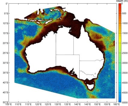
Hydrodynamic model of the Australian coast, MIKE 21 FM modelling software, Danish Hydraulic Institute, (Haigh et al. 2014 Clim Dyn 42, 124)
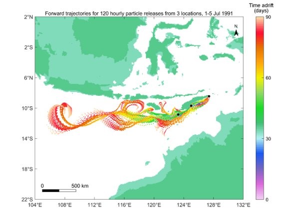
Modelling drift trajectories and duration from Timor to Sahul (Kuijjer et al. 2020)
Seafaring Research
- Ethnographic and archaeological study of maritime technologies, consideration of necessary technology, skills and knowledge
- Study of performance of simple watercraft
- Study of oral traditions surrounding watercraft and seafaring
Explore Indigenous watercraft of Australia here.