
ACROSS is working to understand the changing coastline, paleoenvironment and now-submerged landscape of southern Sunda (Island South East Asia) and northern Sahul (modern day Australia and New Guinea).
Changing Landscapes and Environments
Sea-Level Change
Changes in sea-level associated with glacial cycles have led to significant changes in coastal configurations. Understanding the location and geomorphology of the palaeocoast is a first step in understanding seafaring, population movement or human activity on the coast in the deep past.
Animation from 150,000 years ago to the present (Kuijjer 2020) GEBCO_2014 www.gebco.net, sea-level curve from Grant et al. 2012.
Active Coastal Environments
Coasts are active zones, in addition to an understanding of the sea-level, an analysis of coastal geomorphology through time includes calculations of sedimentation and erosion rates, uplift and palaeoenvironmental change. Understanding the nature of a changing coast through time, can help us understand coastal productivity, and the availability of different raw materials or resources. Equally, working from the ground up, local palaeoenvironmental data can indicate larger regional patterns reflecting climate change, for example periods of aridification or intensity of the monsoon.
ACROSS is using multipole data sources including offshore industry acquired data in order to:
- Create a high-resolution 1st order reconstruction of palaeogeography of the submerged Sahul shelf at various sea-levels
- Analysis of 2D and 3D seismic data for new litho-stratigraphic models
- Use of new models to refine understanding of the palaeocoastline and to provide boundaries for palaeohydrodynamic modelling
- Modelling of palaeomarine environment, ocean and coastal tides, winds and currents (see SEA)
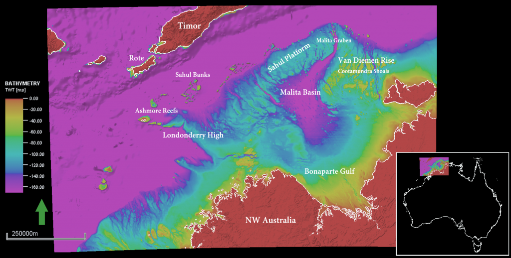
The study area is centred on the Bonaparte Gulf, NW Australia. The present day land position is shown in red. During lowest sea level periods more land would have been exposed – the Van Diemen Rise, Sahul Platform and Londonderry High would have formed islands and promontories far out into the ocean. The sea at these times would only have occupied the areas shown in pink. The emergent landscape indicates the distances that early seafarers may have to have sailed. GEBCO 250 gridded bathymetry (Fogg et al. 2020).
Activity in Coastal Environments and Submerged Landscapes
Understanding the changing nature of the coast at different scales can help us understand early human activity in context. Knowledge of the location of coasts and islands in the past is a vital first step for studying seafaring between them, enabling us to think about distance, routing and tidal and weather conditions encountered (see modelling in SEA). The nature of the marine environment shapes these early voyages and provides us with clues as to the types of early watercraft used and the skills and knowledge required.
More than this, understanding the changing coastal zone can provide us with insight into the coastal landscape encountered and navigated by Sahul’s first inhabitants as far back as 65,000 years ago. Submerged Palaeolandscape Research in the northern hemisphere has demonstrated the importance of understanding these now submerged continental shelves for understanding the deep past (i.e. SPLASHCOS), demonstrating excellent preservation of sites offshore. There is a growing recognition that early sites that could dramatically add to, or alter, our understanding of the human past may also be preserved in these submerged landscapes on the continental shelves in the southern hemisphere SPLOSH. Taphonomy and the chance of preservation on the Sahul shelf will reflect the differing environmental conditions, the types of sites and raw materials, but there is evidence that these sites can be preserved in underwater contexts (Deep History of Sea Country). Through ACROSS’ landscape work, environments which may have been good for occupation or visitation, and areas that may hold a chance for preservation can be mapped, a first step in large-scale submerged palaeolandscape research.